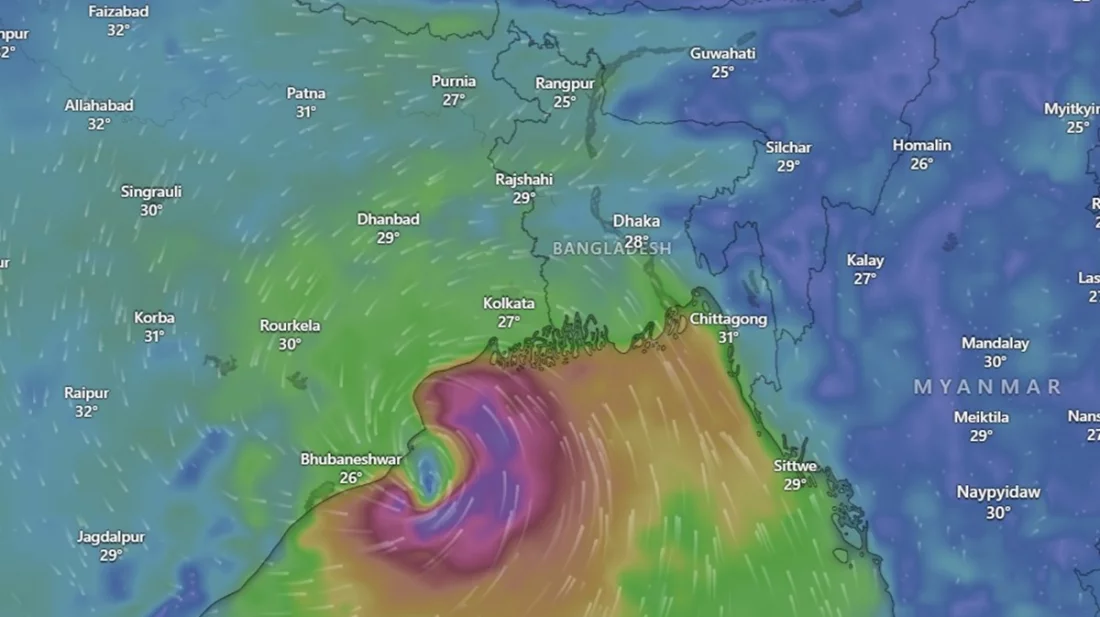
The cyclone ‘Dana,’ formed in the Bay of Bengal, is intensifying as it moves toward land. According to the latest trajectory, the cyclone is expected to make landfall between Puri in Odisha and Sagar Island in West Bengal, India, anytime between 6 PM this Thursday and 6 AM tomorrow, Friday.
Meteorologists fear that this “Very Severe Cyclonic Storm” could make landfall at speeds ranging from 120 to 166 kilometers per hour. Alongside West Bengal in India, Bangladesh’s coastal districts, including Khulna, Patuakhali, Satkhira, Bagerhat, and Barishal, are also likely to be affected. The coastal areas may experience severe tidal surges and flooding. Due to the impact of ‘Dana,’ the skies over various coastal areas of the country have been overcast since Wednesday morning, with occasional moderate to light rain. The intensity of the rain increased last night.
The cyclone named ‘Dana,’ formed over the Bay of Bengal, has intensified and is moving toward the mainland. According to the latest forecast, the storm is expected to hit between Puri in Odisha and Sagar Island in West Bengal, India, between Thursday evening and Friday morning. As of the last update, ‘Dana’ was located approximately 665 km south-southwest of Chittagong Port, 600 km south-southwest of Cox’s Bazar, 640 km south-southeast of Mongla, and 595 km south-southeast of Payra.
The meteorological bulletin mentioned that the cyclone’s sustained wind speed near the center could reach up to 62 km/h, with gusts up to 88 km/h. The sea near the cyclone’s center remains highly turbulent. Ports including Chittagong, Cox’s Bazar, Mongla, and Payra have been instructed to hoist the local cautionary signal number three. Fishing boats and trawlers in the northern Bay of Bengal and the deep sea have been advised to seek safe shelter immediately.
Dr. Muhammad Abul Kalam Mallik, a meteorologist at the Meteorological Department, said that as of last night, the cyclone was moving towards the Odisha coast and might make landfall near Dhamra Port. Even though the cyclone is relatively far from Bangladesh’s coast, the country’s shoreline remains on the right-hand side of the projected landfall path, increasing the potential impact. If the cyclone takes longer to cross the coast, its effects will be felt for an extended period, depending on wind speeds.
Mustafa Kamal Palash, a climate researcher from the University of Saskatchewan in Canada, analyzed satellite data and reported that heavy rainbands from the cyclone began to reach the coastal regions of Bangladesh, including Khulna, Barisal, and Chittagong divisions, from around 7 PM yesterday. Intense to very intense rainfall is expected, especially over areas like Chittagong, Feni, Noakhali, Cox’s Bazar, Bandarban, Rangamati, Khagrachari, and several districts in the Barisal division, including Bhola and Patuakhali.
Meanwhile, the Indian Meteorological Department has reported that the cyclone is likely to strengthen further into a severe storm over the northwestern Bay of Bengal by early Thursday. It is expected to make landfall between Puri and Sagar Island, with wind speeds reaching up to 120 km/h.
In preparation for the cyclone, Bangladesh’s Ministry of Disaster Management and Relief has been in contact with district administrators of coastal areas to ensure readiness. Local administrations have taken precautionary measures in accordance with the Standing Order on Disasters (SOD). Medical teams have been formed, and volunteers from the Cyclone Preparedness Program (CPP) and the Red Crescent are on standby. District-level authorities have been instructed to remain prepared for any situation that may arise due to the cyclone.
Source: Ittefaq


